As an outcome of the City’s Heritage Strategy 2020-2025, Council adopted a new Local Heritage Survey (formerly known as the ‘Municipal Heritage Inventory’) and Heritage List in August 2025, following a review of public submissions.
Background
The City of Rockingham adopted its first Municipal Heritage Inventory (MHI) on 24 October 1995 and it has been subsequently updated in 1998, 2008, 2012 and 2018. Since that time, many places have undergone change and documentation standards have been revised.
In 2023, the City of Rockingham engaged consultants to review the 2018 Heritage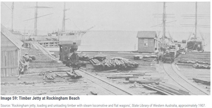 Inventory. The City’s heritage review process included:
- A site visit to photograph each local heritage place and record its condition;
- The accuracy of the land information and historical information was checked;
- New nominations were assessed with a short history of each place;
- Management Categories were all reassessed for each place;
- Some internal inspections were conducted to record significant features;
- The historical story lines were reviewed to include additional information (1960-present);
- Current research on aboriginal presence in Western Australia was included; and
- Additional built fabric descriptions and photographs to places on Garden Island and Rockingham Park Underpasses.
The revised Local Heritage Survey and Heritage List were publically advertised for a period of 31 days. For more information on the consultation with the community and report on submissions considered by Council, please refer to the Council Minutes - Tuesday 26 August 2025.
Local Heritage Survey (LHS)
A total of 100 places were included on the LHS, which has increased by five places, compared to the 2018 MHI. 
- The five new LHS places include:
- Heritage Place No.16 – Corry Lynne House - Site
- Heritage Place No.25 – Scar Trees and Circle of Rocks
- Heritage Place No.26 – Tramway Reserve
- Heritage Place No.45 and 46 - Rockingham Oval and Memorial were split into two (2) separate Places
- Heritage Place No.67 – 1875 Rockingham Townsite (fmr)
- In addition, information relating to the Rockingham Fishing Company was reflected in the history section of the LHS.
- One place was relocated – recorded as the Founders’ Memorial.
- Three places were demolished (or approved for demolition) but retained on the LHS as sites:
- Heritage Place No.49 - Rockingham Fire Station – Site
- Heritage Place No.54 - Rockingham Hotel – Site
- Heritage Place No.91 - 118 Arcadia Drive – Site
Heritage List
Of the 100 LHS Places, 51 were included on the City’s Heritage List. The Heritage List is to be in accordance with the Planning and Development (Local Planning Schemes) Regulations 2015. The LHS must align with the Heritage List, but the Heritage List does not necessarily include all places in the LHS.
The Council included all Places on the LHS with a Management Category of “2” or higher on the Heritage List, but excluded historic sites (where the structure/building is gone – Management Category 4) and Places outside of the jurisdiction of the City’s Town Planning Scheme No.2 (such as Garden Island and Penguin Island). Management Category 3 Places were included by Council where it considered the Place worthy of built heritage conservation, in consultation with the property owner.
Appreciation
After a two year journey undertaking the City’s heritage review we would like to extend our appreciation to the following groups:
- Stephen Carrick Architects (SCA) for a thorough Local Heritage Survey and Heritage List
- Community Place nominations, where some reflected significant historical research
- Long serving members of the City’s Heritage Reference Group (HRG)
- Rockingham District Historical Society (Inc.)
- Mooriboordap Advisory Group
- Gnaala Karla Boodja Aboriginal Corporation (GKBAC)
- The local community.

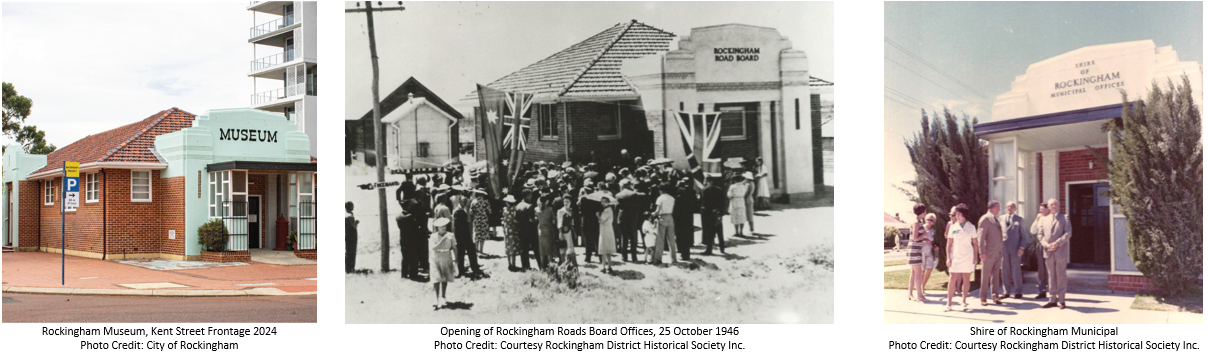
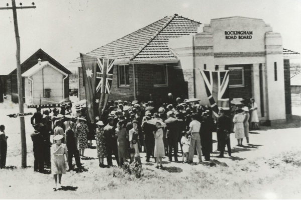
Did you know that the Rockingham Museum in Kent Street, was the Rockingham Roads Board Office (fmr), constructed in 1946 and was the civic hub of the Rockingham district. With growth of the region, the administration offices of the Shire of Rockingham were relocated east of the Rockingham beach settlement in 1971. In 1978, the Rockingham Roads Board Office (fmr) building was offered to the Rockingham District Historical Society (RDHS) and it has occupied this City of Rockingham owned building since 1979.
The conservation of the Rockingham Roads Board (fmr) in its art deco style provides a connection to the historical development of Rockingham associated with the 1915-1949 Inter-War period of development and the Post War transformation of Rockingham townsite from 1950-1971, when roads were widened to cater for increased motor traffic. During the 1970's, Rockingham experienced significant population growth with many new subdivisions established for residential development. The Rockingham Roads Board (fmr) played a significant civic role during this period of economic prosperity.
The adaptation of the Rockingham Roads Board Office (fmr) into a Museum was carefully undertaken to ensure the exterior fabric of the building is relatively unchanged and the interior of the building is also largely intact. When visitors walk through the Museum it demonstrates that the building was used for civic purposes and that is clearly visible. Both the place and Museum help tell the story of the this local heritage place and of Rockingham.
The community use of the Rockingham Roads Board (fmr) building as a Museum for 46 years has helped tell our story and has benefited generations of families living within and visiting Rockingham. For all this time, the RDHS members have generously donated their time to operate the Museum and library history which includes a collection of artefacts which are interpreted from our past, and help to educate and promote Rockingham's history to the general public, interstate and overseas visitors and children.

The Pioneer Member Rockingham Road Board from 1897 take pride of place and there are numerous exhibits reflecting early pioneers, late settlers and all of the subsequent periods of growth in Rockingham. Since 1946, the Rockingham Road Board Office (fmr) setting has dramatically changed with new multi-unit development and nearby 'village green' within the Waterfront Village Precinct, however, this Place still has a strong relationship with the foreshore development of Rockingham.
The RDHS is a member of the Royal West Australian Historical Society and member of Museum Australia. It's members also promote public interest through meetings, speakers on history and exhibitions. They have also hosted school groups. In 2024, the RDHS had 51 members and 21 active members who maintain Museum opening hours between 1pm to 4pm on Tuesday, Wednesday, Thursday, Saturday and Sunday.
If you're interested in the City's heritage or just doing a day trip to Rockingham, the Rockingham Museum is worth a visit.
As an outcome of the City’s Heritage Strategy 2020-2025, Council has considered financial incentives as a means of encouraging the conservation of privately-owned local heritage places in the City.
At its Ordinary meeting on 19 December 2023, Council resolved to adopt the proposed amendments to the City of Rockingham's Community Grants Program (CGP) Policy to include provision for new Heritage Assistance Grants to owners of heritage-listed properties.
From July 2024, the owners of heritage-listed properties may apply for the following Heritage Assistance Grant Categories:
| Grant Category | Local Heritage List- Heritage Management Category | Heritage Documentation | Conservation Works | Total |
|---|---|---|---|---|
| Major | Category 1 - Exceptional Significance | $2,000 | $7,000 | $9,000 |
| Medium | Category 2 - Considerable Significance | $2,000 | $5,000 | $7,000 |
| Medium | Category 3 - Some/Moderate Significance | $2000 | $5,000 | $7,000 |
| Strata Titled Development | Category 1 to 3 Management Category | $2,000 | $7,000 | $9,000 |
Eligible heritage projects for these grants may include up to 50% of the total cost of conservation works, up to the maximum total amounts listed above, and up to 50% of funding towards heritage documentation. The City has prepared a set of guidelines to assist in the administration of Heritage Assistance Grants within the framework of the CGP.
While these funding opportunities will apply to most Local Heritage Places on the City’s Heritage List, some Local Heritage Places which are considered not worthy of built heritage conservation (Management Category 4 and some with a Management Category of 3) will not be eligible.
Applications for Heritage Assistance Grants can be submitted to the City anytime but will only be assessed and considered twice each year. Information on how to apply and the grant application closing dates will be made available at Community Grants Program.
In October 2023, the City’s Heritage Consultant and Archaeological Consultant completed the Peelhurst Ruins Conservation Management Plan (CMP).
The City commissioned the Conservation Management Plan as an update to the first CMP for Peelhurst (ruins) produced in 2011. A CMP is the main guiding document for the conservation and management of a heritage place. Its objective is to ensure that decisions are made with regard to the cultural heritage significance of a heritage place.
A Public Archaeological Dig was a recommendation from over 10 years ago in the 2011 CMP, which was never forgotten. It was a wonderful opportunity for the local community to be invited to participate and observe in an archaeological dig and learn about the processes involved and understand the local heritage significance of the place. Read below for a separate news story on the three-day Public Archaeological Dig, which unearthed items of the past. The welcoming community response and support from neighbours kept the project going through some cold weather with lots of stories shared along the way.
 The dig project was recognised with a Commendation at the Western Australia Heritage Awards held in October 2023 in the Contribution by a Public or Private Organisation category, as part of a three-way collaboration with the City, Heritage Consultant Element Advisory and Archaeology Consultant Terra Rosa.
Peelhurst (ruins) is the remnants of a stone cottage built by Thomas Peel Junior (Tom Peel) in the early 1860s. The cottage was within a large landholding which Tom Peel named ‘Peelhurst’.
The cottage was never completed but was occupied by Tom Peel and his housekeeper Mrs Spencer until approximately 1882, when the property was sold to brothers William and George Paterson.
In 1949 the lot on which the Peelhurst ruins were located was sold to engineer Cyril Robbins. In the 1960s, the large landholding was subdivided for residential lots and sold under the name ‘Golden Bay’. Since that time, Golden Bay has slowly developed from a holiday destination to being absorbed within the greater Perth Metropolitan area.
The lot on which Peelhurst (ruins) is located was transferred to the City of Rockingham in May 2008 and it has been maintained as a reserve since that time.

The City of Rockingham’s public archaeological dig at the Peelhurst Ruins in Golden Bay from Friday 5 May to Sunday 7 May has unearthed a number of items, with the community’s support of the dig making it an archaeological adventure to remember.
The Peelhurst ruins are located on Dampier Drive in Golden Bay and are the remnants of a stone cottage that was built in the 1860s for Thomas Peel Jr (Tom Peel), who was one of the first English settlers in Western Australia. The ruin is included in the City’s Municipal Heritage Inventory and the site was gifted to the City 1991. During the dig the City found several artefacts including a One Shilling coin from 1880, two fully intact bottles (including a Rosella sauce bottle made between 1900 and 1920), a broken table plate that was later able to be pieced together with lettering ‘J. Cromie Hall of Commerce’ we dated back to an advertisement to 1889, and a number of buttons.

The majority of the artefacts at the ruins were found in a stone section, which archaeologists are still considering, but it may have been an old cellar or water well.
Mayor Deb Hamblin said the archaeological dig was guided by the City’s Heritage Strategy and the Peelhurst Ruins Conservation Management Plan, delivered under the supervision of archaeologists and heritage specialists.
“Peelhurst Ruins are a significant heritage site in the City of Rockingham, and the public archaeological dig carried out with the help of volunteers from the community was held with the intent of unearthing potential historic artefacts,” Mayor Hamblin said.
“The City was delighted to see community members attend and observe the dig, which gave visitors the chance to see how an archaeological excavation is setup, what sampling strategies are implemented and the types of tools that are used."
“The level of community interest and the positivity surrounding this archaeological dig was exciting for the City, and it clearly shows local residents are passionate about heritage in their community.”
 In January 2022, the City’s Heritage Consultant completed the Rockingham Road Board Offices (fmr) Conservation Management Plan.
The former Rockingham Road Board Office is located on Kent Street, Rockingham. When the building was constructed in 1946, this area of Rockingham was the civic hub of the Rockingham district. The growth of the region in the second half of the 20th century saw the relocation of the administration offices of the City of Rockingham to larger offices south east of the original Rockingham Beach settlement.
The area of the new City of Rockingham administration offices is now largely the commercial and civic centre of the City with the earlier civic centre alongside the beach front taking on a retail, residential and tourism role.
Since the vacation of the former Rockingham Road Board administration team in 1971, the building had a number of occupants. In 1978, the building was offered to the Rockingham District Historical Society (RDHS) which continues to occupy the former Road Board Office and since 1998, the former library building located to the rear of offices. The RDHS established the Rockingham Museum within the building and it has offered a valuable service to the community as a repository of artefacts and displays that educate visitors about the history of the Rockingham district.
The former Rockingham Road Board Offices are in good condition with some alterations and additions since construction. The most significant addition occurred when a new building was constructed in 1988 to link the library and hall, built in 1962, to the former Rockingham Road Board Office.
The former Road Board Office was included on the City of Rockingham Local Heritage Survey in 2012 and designated as deserving the highest level of protection and management. The former offices are maintained by the City of Rockingham and at present it is envisaged the museum will continue to occupy the building into the future.
The preparation of the conservation management plan will assist in the future management of the built structures on the site through the preparation of policy to guide future development and ongoing maintenance.
In December 2022, the City’s Heritage Consultant completed the East Rockingham Pioneer Cemetery Conservation Management Plan.
The East Rockingham Pioneer Cemetery was first surveyed in 1866 for use by the small community at East Rockingham consisting of traditional burials, lawned burials and niche walls.
The first internment was in 1867, when Joseph Broughton was buried in the East Rockingham Pioneer Cemetery.
Aerial views clearly illustrate the formality of the arrangement of the early graves. The graves are laid out in regular rows, with the first three rows along the western edge being on an angle following the alignment of Mandurah Road.
The East Rockingham Pioneer Cemetery is associated with many of the first settlers who moved to East Rockingham during the 1840s to establish their farms and with the second wave of settlers who consolidated the small community established by those earlier settlers.
There is also a group of graves belonging to soldiers of the Australian Imperial Forces dating from 1918. The headstone contains the name, rank, number and date of death as bearing the badge of the Australian Imperial Forces. The place has associations with the Spanish Flu epidemic which swept around the world at the end of 1918 through the burial of 11 soldiers who died at Woodman Point from this illness.
The cemetery is now managed by the City of Rockingham with some administrative and operational tasks relating to internment activities undertaken by the Metropolitan Cemeteries Board.
The Conservation Management Plan has been prepared to guide routine maintenance and planned development works for this place with reference to the cultural heritage significance of the place.